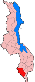
DISTRICTS - SOUTH - CHIKWAWA
- DISTRICTS
- NORTH – CHITIPA
- NORTH – KARONGA
- NORTH – LIKOMA
- NORTH – MZIMBA
- NORTH – MZUZU
- NORTH – NKHATA BAY
- NORTH – RUMPHI
- CENTRAL – DEDZA
- CENTRAL – DOWA
- CENTRAL – KASUNGU
- CENTRAL- LILONGWE
- CENTRAL-MCHINJI
- CENTRAL – NKHOTAKOTA
- CENTRAL – NTCHEU
- CENTRAL – NTCHISI
- CENTRAL – NTCHISI
- CENTRAL – SALIMA
- SOUTH – BALAKA
- SOUTH – BLANTYRE
- SOUTH – CHIKWAWA
- SOUTH – CHIRADZULA
- SOUTH – MACHINGA
- SOUTH – MANGOCHI
- SOUTH – MULANJE
- SOUTH – MWANZA
- SOUTH – NSANJE
- SOUTH – THYOLO
- SOUTH – PHOLOMBE
- SOUTH – ZOMBA
- SOUTH – NENO
Chikwawa is a sprawling town of around 12,000 set on the west bank of the Shire 50km south of Blantyre at the junction of the M1 and the feeder road to the Majete Wildlife Reserve. The area immediately around Chikwawa is of interest mainly to bird enthusiasts. About 1km out of town, in September, a nesting colony of carmine bee-eaters can be reached by following the dirt road opposite the police station to the west bank of the Shire River. On M1, about 3km south of the turn-off to Chikwawa, the Kasinthula fish ponds are noted for waterbirds, particularly the large numbers of migrant waders which are attracted to the area between July and December.
Lower Shire
Southwest of Blantyre, the M1 snakes and slithers down the Thyolo Escarpment into the steamy lowlands of the Lower Shire Valley, a tapering wedge of Malawian territory surrounded by Mozambique on three sides. It’s a dramatic drive, with lurching hairpin bends offering awesome views across the of Majete Wildlife Reserve into Mozambique, then finally the meandering Shire river comes into view, flowing southward to its confluence with the Zambezi. This southern most silver of Malawi retains the feel of wild, untrammelled Africa: the wide lush Shire River still supports prodigious numbers of hippo and crocodile, a trio of protected areas harbours a variety of terrestrial wildlife, and urban centres such as Chikwawa and Bangula come across as strikingly un-Westernised by comparison with Blantyre.
This was the first part of Malawi to be documented by Europeans. In January 1859 Livingstone’s Zambezi Expedition steamed up the Shire until its path was blocked by the Kapichira Falls, in what is now the Majete Wildlife Reserve. When Livingstone travelled up the Shire again in 1861, to help Bishop Mackenzie establish the first mission in central Africa, the region was controlled indirectly by Portuguese slavers. By 1863, when Livingstone made his final trip here, the slave trade had transformed the Shire into ‘literally a river of death’, according to his companion Dr Rowley, its banks lined with dead and emaciated Afrians. And the malaria associated with this low-lying riverine habitat proved to be equally deadly to several expedition members: Bishop Mackenzie died on a now submerged island at the confluence of the Ruo and Shire in 1862m, and two other clergymen, Reverend Scudamore and Dr Dickinson, died in the Chikwawa area in 1863, along with the 25-year old geologist Richard Thornton.
The main attractions of the Lower Shire Valley today are the raw beauty of the riverine landscape and a high diversity of mammals and birds. The region supports three officially protected areas, namely Majete Wildlife Reserve, Lengwe National Park and Mwabvi Wildlife Reserve, and there is also the private Nyala Park (set in the Nchalo Sugar Estate) and the unprotected elephant Marsh. Despite this, the lower Shire Valley doesn’t see a great deal of tourism, though this may well change as a result of the recently implemented programme of reintroduction of Majete. The reserves are most easily explored in a private vehicle, ideally a 4×4, but the elephant March is readily accessible to backpackers.
However you visit, be prepared for some serious weather – this is the lowest lying part of Malawi, dropping to 38m above sea level near Nsanje, and temperatures of 35-40°C are common place is summer – and be aware that malaria is rife. The best time to visit on both fronts is from June to August, when the weather is reasonably cool and dry, and this is also the best season for game viewing. Be aware, too that this part of Malawi is conspicuously lacking in modern facilities such as internet cafes, ATMs and forex bureaux.
What to see in Chikwawa
Accommodation
If you require any further details with regards to accommodation please email wawamalawi@africamail.com and we will happily recommend a place.
Getting There
The southern extension of the M1 starts at Blantyre and runs all the way through the Shire Valley to the remote Mozambican border, past the towns of Chikwawa, Nchalo, Bangula and Nsanje. The first 39km of this road, as far as Kanjedza, is very steep in parts, and it’s not unusual to be trapped behind crawling trucks for long stretches, so allow plenty of time. The M1 is tarred until just after Nchalo, while further south it is mostly unsurfaced or so heavily pot-holed as to make no difference. Plenty of buses and minibuses traverse the M1 between Blantyre and Nsanje, but there is little or no public transport on other roads in the area. The three official protected areas all lie to the west of the M1 along feeder roads of variable quality, and are best explored in a private 4×4, especially during the rainy season.
Briggs, P. (2010). Chikwawa. In: Briggs, P Malawi. 5th ed. Connecticut: Bradt. p210.